Wednesday, February 8

Principle and Power in Federal Transportation

The Republican majority in the federal House of Representatives laid down the gauntlet last week in what is shaping up to be a dramatic fight over the future of transportation in the United States. The Transportation and Infrastructure Committee passed their bill along partisan lines, while the House Ways and Means Committee ousted transit funding entirely from the Highway Trust Fund.

These proposals have instigated strong reactions. Transportation Secretary Ray Lahood, a moderate Republican, called it "the worst transportation bill I’ve ever seen during 35 years of public service.” Federal Transit Administrator Peter Rogoff considers it “a huge step backward.” The New York Times and Los Angeles Times issued scathing and unequivocal editorial rebukes.

Whether or not this bill makes it through the full House in its current form, or through a compromise with the much more bipartisan Senate, it's at least serving the useful purpose of drawing widespread public attention to a clear decision before the American public. In the interest of paying attention, I've cobbled together a few principles that have generally been used to evaluate federal transportation policy. I believe they are all sensible, even if they do not fit together as neatly as one would like.
 
User Pays, User Benefits

What makes the marketplace, in general, such an effective tool for allocating resources is the alignment between the costs of a decision and the benefits accrued to the decision-maker. If you buy the stick of gum, you get to chew it. If you want gum, you have to pay for it. Because of this linkage, each of us is able to perform hundreds of tiny cost-benefit analyses everyday, using our own preferences and brainpower, to maximize quality of life and minimize waste. In the aggregate, goods and services are shifted to where they are used most effectively.

Because of monopolistic tendencies, transportation infrastructure cannot be fully handed over to the private market. However, at least since the Federal-Aid Highway Act of 1956, officials have tried to emulate its logic by requiring infrastructure to be paid for directly by those who benefit from it, and in proportion to the benefit they receive. A user fee sends a price signal to the consumer, empowering each person to decide what travel is worth to them, while also sending an investment signal to the government provider, allowing it to allocate more funds when more maintenance and capacity is necessary.

The gas tax, the primary user fee feeding the Highway Trust Fund, has been imperfect. You pay a fixed amount per gallon, whether 100% or 0% of the miles driven are on federally-funded roadways. Hybrid vehicles pay much less than automobiles with traditional combustion engines for the same product, and electric vehicles pay nothing at all. For these reasons and more, transportation analysts are in hot pursuit of a more comprehensive VMT fee. But, for now, the gas tax is the best we’ve got.

The House transportation bill has been criticized from across the political spectrum for breaking the User Pays, User Benefits precedent. The bill expects to make up for a $50 billion revenue shortfall by selling leasing rights for oil extraction in Alaska and off-shore, a move the Competitive Enterprise Institute has labeled “drilling for roads.” Even if (big if), enough money is eventually generated by this scheme, getting the horse back into the barn of a closed fiscal loop will be very difficult politically.

Transportation analyst Alan Pisarski cautioned:

"The loss of the user pays principle would further diminish the trust fund and the whole concept of a balanced relationship between spending and use."
Internalize Social Costs

If we want individuals to be able to set national priorities by making hundreds of tiny cost-benefit analyses throughout the day, then each person ought to be shouldering the true costs attributed to their actions. The fact is that, more than any other mode of travel, driving imposes costs that are not paid by the driver. The Freakonomics guys put it this way:
"What are the negative externalities of driving? To name just three: congestion, carbon emissions and traffic accidents. Every time Arthur gets in a car, it becomes more likely that Zelda — and millions of others — will suffer in each of those areas."
They estimate these costs to be about 10 cents a mile, or the equivalent of a $2/gallon gas tax. As a point of reference, the federal gas tax has stood at 18.4 cents/gallon since 1993. (If you happen to believe that global climate change is an international hoax perpetrated by scientists, then you can feel free to shave 13 cents off their gas tax estimate). On top of this, some other costs forced upon non-users are non-residential parking, air quality, stormwater runoff, and noise and aesthetics. Obviously, reaching an agreement on the exact price of all of these values is difficult, but intangible costs are real.

Sometimes the User Pays, User Benefits principle and the Internalize Social Costs principle are presented as mutually exclusive, as if the gas tax can either be only a user fee or a tax. But it can certainly be both, as long as the funds generated are used to benefit the user as well as offset the costs imposed by the user. There are many ways to offset the costs, spending on transit historically being the most significant.

The Safe Routes to School Program is a good example of an internalization of social costs. There's nothing inherently unsafe about children walking to school, at least since humans neutralized threats from large predators. However, the presence of automobile travel introduces a new threat that either endangers schoolchildren or forces them to shift over to more costly modes. That's why it makes sense for each driver to chip in about a dollar a year to offset this impact. The House transportation bill would eliminate Safe Routes to School, along with all other programs dedicated to walking and bicycling.

Scale to Geographic Range of Impact

Two hundred years after Hamilton and Jefferson argued over federalism, the debate between state and federal power in the United States has never been adequately resolved. At least in theory, the answer to this question for transportation can be determined empirically: the scale of governmental authority over a system ought to match the geographic range of impact from the system. This was essentially the conclusion reached in 1987 by the (now defunct) U.S. Advisory Commission on Intergovernmental Relations:
This concept of the geographic range of highway benefits is a key test to determine which unit of government should bear responsibility for highway finance.”
According to this test, the entire transportation network can be teased apart, from federal interstate and intercity rail to neighborhood roads and trails, and responsibility assigned to the scale of government that matches the particular component. Grey areas can be smoothed out by cost-sharing ratios or various kinds of block grants passed between governments.

The ACIR was right to focus on the geographic scale of the network, but they were wrong in a few ways. First, actually sorting infrastructure by scale is hard to do. They considered the Interstate Highway System the classic case of national interest, but, in reality, many interstate trips made within metropolitan areas will never cross a state line. Motorists use the interstates for commuting, bypassing congested local roads, and various other daily tasks. If the federal role in transportation were selectively limited to highways alone, it would introduce a host of distortions into the regional and local systems, forcing them to accommodate an inefficient overemphasis on driving. The federal government, in this case, would have the responsibility of offsetting its own impacts.

Secondly, they only considered the geographic range of benefits, without considering the geographic range of costs. Air pollution drifts across state lines, all U.S. citizens share the costs of treating crash victims through insurance premiums and medicare/medicaid, and carbon emissions are global. There is certainly a federal interest in keeping these costs down.

The House bill is being sold as a further step toward devolution of federal control to the states, but no spatial evidence has been provided for why the current balance should be shifted in that direction. Scale changes over time. A small metropolitan area may have once had a transportation network that could easily be contained within a state boundary, but the emergence of megapolitan areas might necessitate passing government oversight up the ladder to some degree.

Fix it First

The lifetime costs of infrastructure should be accounted for in the original decision to build. In other words, maintenance takes precedence over new construction, and federal funding formulas ought to appropriately prioritize it. This is simply a manifestation of the broader principle: live within your means. Deferral of maintenance is exactly the same thing as taking on debt. The interest rate may start out low, but it is ratcheted upward exponentially by the bank of physics. And physics cannot be bailed out.

A 2011 Report by Smart Growth America showed that states spent 57% of their federal appropriations on building new roads, while simultaneously accruing a backlog of maintenance on existing bridges and highways. The same organization calls the House transportation bill, unlike its equivalent in the Senate, still short of the mark in resolving this.

Provide Accessibility over Mobility

It’s not about the journey; it’s about the destination. Most of us travel in order to achieve a purpose that has nothing to do with transportation: visit your parents for dinner, work at the office, see Yellowstone, deliver a package to a customer. The old paradigm of transportation planning held that maximizing mobility was the primary purpose of the system, and the metric of success was defined in terms of vehicle miles traveled. But mobility is just one means to an end. The ultimate goal of transportation is to empower humans to meet their own goals by connecting where they are with where they want to be.

The paradigm shift from mobility to accessibility brings multimodal travel options and the interconnections between transportation and land use into sharper focus.Todd Litman says:
"An efficient transport system is multi-modal, encouraging travelers to use each mode for what it does best: walking and cycling for short trips, ridesharing and public transport for travel on congested urban corridors, and automobile travel when it is truly most efficient overall, taking into account all impacts."
The House bill would maintain the current federal funding formulas that reward states for inducing more driving. State A with destinations spread out from each other would be considered more "successful" in providing mobility than State B with dense cores of activity, even if State B actually facilitates more connections between origins and destinations. State A would be apportioned more federal funds.

President Obama's Sustainable Communities Initiative has been a tentative first step toward this more rigorous and robust understanding of transportation. The House transportation bill does not attempt to build upon this discussion in any recognizable way.

Support Household Resilience

Even if the federal government does manage to balance its transportation budget, this achievement would matter little if it has the effect of pushing struggling American families further underwater. There is a broad moral consensus that each individual deserves the opportunity to better oneself through hard work and personal responsibility, but the reality is that holding a job and operating a household are preconditioned upon an affordable and reliable means for getting around.

Americans that live in a place with no options beside driving face constant pressure, what the New America Foundation refers to as the "Energy Trap."
"Every 25 cent jump in the price of gas siphons $90 million a day away from the recovering American economy. Because we have few choices but to commute to work in private cars, we are trapped by high gas prices.

The energy trap is particularly hard on American households. The average family of four making $50,000 a year spends nearly $8000 a year on their cars, maintenance, and fuel combined--more than they pay for taxes or medical care."
It's is important to note that a car-dependent system of transport not only restricts the 9.1% of American households without a vehicle available, but it squeezes those who are able to scramble together the funds to provide personal mobility. Families under pressure are less likely to take risks on their career, and may neglect other important elements of their budget. And one little leak in the hull, maybe a few more dollars at the pump or a "check engine" light, might just sink the ship.

Create jobs

We've come to expect politicians in recent years to tout the job creation potential of their proposals, so it's not surprising that the House transportation bill even includes the word "jobs" in its title. While the primary purpose of federal transportation may be to connect people with their destinations, the bill is also rightfully judged by how the planning, construction, and operation of the sector itself moves money through the economy.

In one sense, all government spending creates jobs (the money has to go somewhere, right?). But not all spending is equally constructive. An analysis of the funds spent on the 2009 American Recovery and Reinvestment Act (ARRA) showed that:
"For every billion dollars spent on public transportation projects, 16,419 job-months were created. A billion dollars spent on highway infrastructure projects created only 8,781 job-months."
This is because ARRA transit projects spent less on land acquisition and raw materials and more on hiring labor with a diverse skill set to operate and maintain the system. Another study came to the same conclusion, only adding that infrastructure for bicycling and pedestrians created even more jobs per dollar spent.

Americans are going to eventually grow tired of empty "jobs, jobs, jobs" platitudes. The operative question is how much stable job creation is generated per dollar spent.

Power

The cynic wonders whether any of this matters.

Any bill will result in winners and losers, at least in the short-term before private interests are able to adapt to new conditions. Many of the largest interests are vested in pushing the transportation system along it's current trajectory. The Center for Responsive Politics has tracked over $13.5 million in campaign donations from the oil and gas industry toward candidates in the 2012 election, almost 9-to-1 going to Republicans. Oil executives, who understand the concept of return on investment, will likely be pleased if they can manage to open up new supply fields, solidify their demand from a car-dependent American populace, and even get a new Keystone XL pipeline thrown in as a cherry on top.

Then there are the voters. Yonah Freemark has shown a strong correlation between density and political affiliation, with Republicans much more likely to live in more sparsely populated congressional districts than Democrats. Constituents who may be accustomed to driving are probably less likely to approve investing in alternatives than those who stand to benefit directly from them (full disclosure: I own a house next to a bus stop). Although there are two major caveats here: some suburbanites live in locations that could potentially become transit-oriented and walkable with further investment, and there are some rural and exurban denizens who like it that way and don't necessarily want to see a new highway drop a big box store in their backyard.

Transportation really should be a pragmatic political arena. There are no deep moral conflicts that transcend the purview of reasonable conversation. Democracy functions best when citizens are able to think carefully about the alternatives before them, and the wake up call from last week may be just in time.

Monday, November 28

In Search of the Megapolitan Scale

When Jean Gottmann popularized the term Megalopolis in the 1960's, he mostly had the Northeast Corridor in mind. By this time, so many interconnections had developed between the string of cities from Boston through Washington DC that it could be referred to as a single unit. Arthur Nelson and Robert Lang, two noted planning academics, continue this line of reasoning in their new book  Megapolitan America, only now highlighting eleven Megapolitan Clusters around the United States. While this nation is a very large one spatially, a significant chunk of economic activity, real estate development, and innovation takes place on only 17% of the privately-held land area. The authors argue that this reality should effect how we conceive of ourselves as a nation.

This is more than just a battle over geographic nomenclature. Once the boundaries of regions are widely accepted, they can define the scale of public and private activities and shape the impact of these activities. The cities of Dallas and Fort Worth formed with completely separate self-images, until a short while after the Census Bureau labeled them a single metropolitan area based on a quantitative definition. The change triggered an adjustment in the federal aid formula used by the FAA, and the two cities were compelled to cooperate on the construction of a single airport. This launched a string of practical joint actions, out of which the single identity of "Metroplex" emerged - the result of a convergence of both top-down and bottom up forces.

So how do you find a Megapolitan Area? If urban systems are dynamic, the boundaries of Megapolitan Areas must be defined by movement. This is a fundamental insight Nelson and Lang adopt from Gottmann and decades of Census Bureau practice. It may be tempting to define regions by drawing a circle around concentrations of stuff, whether population (where people sleep at night) or employment (where those who work in a fixed place spend a large portion of their week), but the movement of people, goods, water, animals, energy, and whatever you can think of through space is what connects places together.

The authors use commuting data to define the shape of Megapolitan Areas, mostly because it's readily available. This works as a proxy but it also misses a majority of human movement, even most work-related travel, since our daily travel patterns are becoming more diffuse and harder to define on a two-point scale. What if you travel to the local office three days a week, work from home sporadically, and visit the regional headquarters a few times a month? Here's where Google or Apple could step in. They've both been amassing huge databases of personal locational information from smartphone users, at least those who have opted in. You can imagine meandering lines on a map, one for each individual path, crisscrossing into a jumbled mess. What most resembles a massive hairball? There's your Megapolitan Area.

If Megapolitan Areas are defined as such by numbers, they remain that way with a story. Nelson and Lang use the apt word "organic" to describe a region that captures the public imagination by tapping into an already understood sense of place. Language is notoriously hard to dictate by fiat, which is why Americans still measure temperature in Fahrenheit. Even if the Census Bureau is convinced to create a new category for megapolitan areas - and the book makes a good case for it - the label will not have much currency until it is accepted by media outlets and the general public in each individual community. They also need a catchy name.

Two very different prognoses for the Sun Corridor
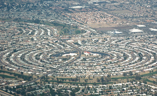
Much of the book focuses on projecting population growth and development out to 2040, in order to predict the continued importance of Megapolitan Areas well into the 21st century. Suffice it to say that the authors are pretty bullish on American growth, expecting it to continue in roughly the same trajectory it has been on for the last several decades, not withstanding our major housing hiccup. Seeing that Las Vegas and the Sun Corridor (Phoenix to Tucson) are slated to be among the fastest growing regions brought to memory an image from a couple of weeks ago. James Howard Kunster was addressing the CityWorks (X)po in Roanoke, Virginia. He showed an aerial photo of houses stretching into the Arizona desert, then quickly remarked, "oh yeah, and Phoenix is toast. There will be no Phoenix" before moving on to the next slide.

So what do you do when two people whom you respect differ in their forecast by ... oh, nine million or so? Well, you cut the difference. Kunstler is clearly being hyperbolic. There's too much vested capital in these Megapolitan Areas for even the worst-case scenario to simply erase them. On the other hand, Nelson and Lang could stand to internalize the possibility of resource scarcity into their projections. They've written a whole chapter on the pressure megapolitan growth will exert on farmland, water, and air quality, but they don't seem to accept that these pressures, in turn, will shape the built environment in a measurable way. For example, the authors point out that water use in the dry Sun Corridor, which is the highest per household in the nation, will have to be reduced somehow. But will those restrictions curtail business? Will future sunbirds be deterred if they can't have the lawn promised in the brochure? That's easy ... yes. Growth will slow down.

But quibbling about the exact distribution of population would be missing the point of the book, and the authors are appropriately cautious in the epilogue with looking so far into the future. The question is whether the definition of Megapolitan Areas will continue to accurately reflect the American pattern of development into the future. Charles Darwin noticed two kinds of taxonomists, the "lumpers" who saw few species and the "splitters" who saw many species. Likewise, reasonable people could look at the same Megapolitan Areas and see many metropolitan areas connected to each other rather than a single whole. Or even a whole galaxy of neighborhoods and employment centers.

This is not a problem. Really, we need as diverse a taxonomy as we have problems to apply it towards. The authors make a strong case for using the megapolitan scale for planning national rail infrastructure, which fits nicely because of the needed density and optimal range inherent to this technology. Some economic development efforts, at least for global markets, would work well at the megapolitan scale, but in other regional markets businesses and communities would be better served by competing with each other.

However, there are points in the book where it feels like the Megapolitan scale is being championed as a superior way of dividing up the nation, rather than just another tool with some good applications. I'm personally very fond of the terms "urban" and "rural" and everything they connote, so it would be sad to see these traditional distinctions melted away into one big megapolitan stew. After all, it's just as legitimate to use labels on the basis of how we want the world to be than on how it currently is. Megapolitan Areas also have the liability of not being exhaustive, which makes the old-fashioned state boundaries more appropriate for applications where complete inclusiveness is necessary.

I'm happy to think in terms of Megapolitan Areas and use the term in the way Nelson and Lang present it, along with several other geographical constructs that have their own appropriate uses.

Thursday, October 20

Instant City: Life and Death in Karachi

Reading a book by an NPR host is a different kind of experience. So was the case with Instant City: Life and Death in Karachi. As Steve Inskeep shares his impressions of Karachi's explosive urban growth, I could almost hear the subtle enthusiasm in his voice over the crunches of granola in my mouth. Fortunately, his skill for parring down complex subjects into bite-sized remarks translates well onto the written page.


Something like a city-wide version of Maslow’s hierarchy of needs shows up in various forms throughout the tale of Karachi’s growth. Faced with an ongoing tidal wave of immigrants from rural areas, urban planners and developers alike tried over the years to shape that growth into a desired form. However, in the absence of more basic government services such as security, sanitation, and public infrastructure these higher-level organizational schemes had no chance of actually working. If prospects did seem good for a moment, the regime would change and it would be all over.  In many cases, city officials and businessmen would import ideas from the West, often directly through global consultants, without paying enough attention to the very different political reality on the ground in Karachi.

The 50-year-old suburbs of Korangi and North Karachi are apt examples. Inspired by the West’s suburban expansion in the 1950s, Pakistan’s ruling general Mohammad Ayub Khan envisioned many of Karachi’s poor lifted into decent suburban lifestyles to the north of the city. With help from the Ford Foundation, the famous Greek planner Constantino Doxiadis was hired to create, from scratch, a self-contained community for at least a half million people. Doxiadis was careful to take design cues from local architecture and cultural preferences, but the design – and he recorded doubts about this in his journal all along– just could not be fitted to Karachi’s economic situation.

Although tens of thousands of families were relocated to these suburbs, problems arose immediately. First, the proliferation of privately-owned automobiles that made American suburbanization possible just weren’t there. Workers who had always walked now had to improvise bus services and pay to commute to their modest jobs across the city. Along with transportation, the residents just couldn’t pay for the houses they lived in, even with heavy subsidies. Without funds to continue, the city-building was cut short. Although Doxiadis had every intention of integrating rich and poor, the opposite happened. The suburb served as a mechanism for pushing the poor to the periphery of the city, which is how Karachi is arranged to this day. Finally, the carefully laid out designs eventually eroded away as unauthorized settlements filled in the open spaces and yards. The end result was the kind of informal settlement the entire endeavor was intended to alleviate - only now miles away from the center.

Other lofty goals were thwarted. A lavish casino had to be torn down before ever opening when the tide changed and the temptation that Muslims might gamble was no longer acceptable. A grassroots movement to save a national park from encroaching development ended with the assassination of two leading neighborhood activists. The essential functions of placemaking, whether from citizen-activists, developers, or planners, were all drowned out by the deeper needs of security and at least a certain degree of political stability. There is no use putting the cart before the horse.

Sunday, October 16

Visions for an Urban National Park

I'll admit that I had no idea a reasonably large national park existed within the boundaries of New York City. Even after a short-lived but legitimate childhood obsession with national park trivia, and after having worked in a national park in Wyoming for a little while, this urban recreational area escaped me. That is until opening Gateway: Visions for an Urban National Park, a book recently released from Princeton Architectural Press. It catalogs the collaborative effort between the National Park Service and a host of designers, mostly landscape architects, in telling the story of this park while continuing to write it.

Maybe I missed Gateway, because it has yet to find a clear identity. As Alexander Brash, a director in the National Parks Conservation Association, writes "Gateway really has no clear thematic past, nor has an easily recognizable and unifying vision for its future been embraced."
  • Gateway is split in to three units: Staten Island, the Jamaica Bay section of Brooklyn, and Sandy Hook in New Jersey. There's no clear way to tie them together. 
  • Gateway's history is split between a location of early native Lenape trails, the site of NYC's first airport, and America's largest World War II naval base. Less glamorously, it contains a quarantine island that housed sickly immigrants, as well as the final and gruesome destination for most of the city's 19th century transportation system. 
  • Gateway is an important estuary for migratory birds, but also a grand experiment in the remediation of over a century worth of unmitigated pollution. 
  • Gateway also functions essentially as a regional park for seven million people a year, allowing many to benefit from a national park who may otherwise never visit one.
The park's complexity is what makes it such a compelling topic for the design competition. Some of the ideas generated can be more feasibly implemented than others, but, in this case, that's fine. The goal was never to select an out-of-the-box design to be built but rather to generate a host of concepts that could help re-envision the park's future. While the NPS will never actually construct thousands of hydroponic pontoons and push them off into Jamaica Bay, the picture of these floating pods underscores Gateway's need to adapt to the shifting interface between water and land after climate change. This was a major theme that many designers picked up on.

Others focused on the park's almost teasing sense of accessibility. While located very near millions of people, it's barely out of reach of the subway and planned ferry services throughout between park sites never materialized. Jamaica Bay became another of Robert Moses' victims when he cut off access from Brooklyn neighborhoods with the Belt Parkway (although, to be fair, Moses also oversaw construction of the popular Jacob Riis park in Gateway). Many proposals tie together ferry lines, subway extensions, multiuse trails, and even overhead cable cars to unify the park and the city.

Of all the parks features, by far the greatest attention was paid to the abandoned Floyd Bennett Field,  with its crumbling runways and nameless structures scattered around. This is a canvas to good to pass up. An editor of the volume, Kate Orff describes Gateway as "post-picturesque," in contrast to Olmstead's Central Park.
"Just as Central Park's construction sharpened our concept of 'the public realm' for an industrializing New York City, re-envisioning Jamaica Bay as a thriving cosmopolitan ecology would further evolve the concept of public space based on stewardship and cultivated wilderness for post-industrial contexts."
If the National Park System has traditionally evoked transcendence through spectacular natural beauty or historic narratives, Gateway could be something different. One of the designs had members of the public walking through each stage of a water treatment process. From the point where the effluent flows in, through a series of settling pools,  and into a restored marsh. At first, I was skeptical. I doubted that families would really bother to follow the informational signage through this seemingly mundane process. But why not? Where else is this kind of story being told?

Tuesday, September 6

Which is denser: New York or Los Angeles?

Your intuitions are correct. New Yorkers live in neighborhoods with much higher density than do Angelenos. But its not obvious how this conclusion is reached, and there's plenty of confusion going around about measuring density. Where you draw the lines on the map can have a significant impact on the results you get.

If you measure density purely regionally, Los Angeles comes out ahead. I've used the Census Bureau's MSA to show the two metro area's population densities in 2010. Sometimes the geography of Urbanized Area is used to capture the region, but that hasn't been determined for 2010 yet. So the MSA will do ...


However, this measurement misses the important story. As Ryan Avent explains,
"Simple population density measures the average density across a particular area. If you have a metro that covers a large area but which features a very dense core, however, you can easily have a situation in which the vast majority of the metro’s population lives at densities above the average population density. I think it’s more informative to focus on weighted-average population density."
  So here's the weighted-average density (by census tract) for the two metro areas:


New York metro goes from being about 30% behind LA in regional density to more than doubling LA in average neighborhood density.

If you were to drop from a parachute flying over the center of a city on a very windy day, the first regional density figure would tell you how many people to expect to see in the square mile around the random place in the region you land. However, if you currently live in the New York or Los Angeles metro areas (or are considering moving there), the latter figure would tell you how many people you would expect to see in the square mile around you. It's tethered to actual human experience, which is usually what we are asking about when we talk about density.

Thursday, September 1

London Bus Tour

This is a wonderful video shot during a course of 30 hours riding a London bus. Every person the bus passes seems to have their own story, even if only captured in two-second film clips. I don't think I've seen a more humane portrait of a great city.


London Bus Tour from moritz oberholzer on Vimeo.

Saturday, August 27

Harlan Douglass: The Little Town

I've decided to resume reviews of books from the the first wave of City Planning in the early 20th century. I'm reading them because a) they're free (copyright expired) and b) there might be something to learn from this period that still applies. Here's the list so far:

  1. Garden City - Ebenezer Howard
  2. Town Planning in Practice - Raymond Unwin
  3. City Planning with Special Reference to Planning of Streets and Lots - Charles Robinson
  4. New Ideals in Planning - John Nolen
  5. The Little Town - Harlan Douglass
  6. Cities in Evolution - Patrick Geddes (upcoming)
All of these reviews are truthful, but they are also selective and editorial. I'm not a trained historian; I only play one on TV. In other words, don't steal this for your class paper. I don't care, but you're professor probably will.

The Small Town Ideal

Americans, today, have a schizophrenic relationship with small towns. We consistently tell pollsters that we want to live in one above any other kind of place, yet we just as consistently choose not to. The Atlantic just ran a story about an idyllic small town in Missouri that, like many around the county, can not attract enough doctors. They've determined that it's not the economic incentives, but the lifestyle that's deterring them. Even small towns that have been engulfed by expanding metro areas tend to receive a scant share of the new arrivals compared to the exurbs around them. Yet the ideal lives on and we like imagine ourselves on the inside of a tight community as we enjoy, at the same time, our freedom from its responsibilities and constraints.

The small town ideal did not exist in 1921. Harlan Paul Douglass wrote The Little Town especially in its rural relationships as a heartfelt defense of what was, in the eyes of many, a pitiable character. He quotes the president of the American Civic Association: "God made the country, man the city, but the devil the little town." From the urban perspective, the townsfolk were unsophisticated, incurious, and many steps behind the moving edge of history. At the same time, rural areas were being lauded by the "county life movement," which had made substantial inroads into the federal government. The farmer was the hero, and the townsfolk were, at best, parasitic middlemen and, at worst, emissaries of corruption from the big city. Farmers were beginning to pull their kids out of town schools and look for a nice field to start their own.

Those who lived in little towns were no easier on themselves. They wanted nothing more than to be the next Chicago, and this overwrought ambition led many to foolishly invest in lavish infrastructure only to be bypassed by the railroad company and left with a dusty, wide main street. Douglass wanted to study and plan for the little town, along with its connected rural areas, as a kind of place that deserved its own category. His aim was to "make it the centre alike of inspiration and administration in the reconstruction of rural civilization."

The Walkable Town

Douglass noted that the maximum size of a town was a function of the walking radius from a single core, enough room for about 5000 people at most. This was the threshold before investment in streetcar lines would have to be justified, creating a natural plateau. With public buildings and business operations at the core and residences surrounding it, every person remained connected to the same sphere. Even the women busy tending their homes could still make it downtown several times a day. The outer ring of the town he calls the "black belt." These were the slum-farms that invariably popped up just outside of a comfortable walking distance but not far enough away to require a motorcar or a team of horses. The farms were small and their buildings created a depressing entrance corridor into the town.

The scale and common center of a town created a unique physical space for diverse interactions. According to Douglass, "no other community enjoys such close daily fellowship with men of so wide a range of vocation or calling." Professional classes in the larger cities would cluster in distinct social groups and neighborhoods, but the size of the small town forced interactions across these lines. Yet there were also physical features of many towns that did create an impediment to interaction. Groups lived on the "other side of the tracks" or "across the river." In these cases mere physical access was directly translated into economic and social access. Douglass believed that,
"a well-planned town with its civic centre is both a means and impulse to social integration, and to the realization of the common life of its people. The physical plan to a town is this as fundamental as the skeleton to the human organism."
This is a notable stance to take, considering that some other planning advocates were, at the time, considering how zoning could be used to properly separate social classes from one another.


The Natural Political Unit

The primary aim of Little Towns is to depict individual towns and their surrounding countryside as interdependent units making up a single "natural community." Despite the significant differences in lifestyle - rural areas were still without electricity - and cultural outlook, the two kinds of places relied on each other economically and socially. Proving that tacky neologisms have always been with us, Douglass liked to use the work Rurban to describe this synthesis.

A central problem consisted in the mismatch between these natural communities and existing political boundaries. So, for example, a farmer would need to travel into town to sell crops, buy goods, and attend church, yet the incorporation of town limits precluded him from the political sphere. The farmer was not expected to pay taxes for the town's function, and he did not have a voice in town matters. Towns compensated for this imbalance by taxing trade, which Douglass believed was underscoring an antagonistic relationship. The farmer then viewed the town as a miniature fiefdom funneling away a portion of his labor, rather than as his own community. For their part, townsfolk considered their rural counterparts to be outsiders.

Douglass believed this could be remedied by a simple exercise. Conduct a scientific town survey to determine the trade area, the availability and use of roadways, and the social identification people declare. Once a map has been made empirically showing the use of services and town identity, the arbitrary political boundaries should be replaced with new ones that match reality. If necessary, multiple zones drawn concentrically from the core outward could be created to define classes with different service needs and different funding responsibilities. Interestingly, Douglass' approach is very similar to later regionalists like Louis Mumford or, much later, Myron Orfield, only at the much smaller rural scale.

As enticing as this solution appears, there remains the challenge of geographical change to deal with. The boundaries of the natural community are always shifting, yet institutions are much stickier. Not only must local governments deal with the transaction costs of redrawing jurisdictions on a regular basis, vested interests start to accrue over time that eventually solidify the boundaries as they are. Annexation was the tool used to deal with spatial change for many years, but this has become politically impossible in most regions. There has yet to emerge another tool that effectively accomplishes what Douglass set out to achieve.