Monday, November 28

In Search of the Megapolitan Scale

When Jean Gottmann popularized the term Megalopolis in the 1960's, he mostly had the Northeast Corridor in mind. By this time, so many interconnections had developed between the string of cities from Boston through Washington DC that it could be referred to as a single unit. Arthur Nelson and Robert Lang, two noted planning academics, continue this line of reasoning in their new book  Megapolitan America, only now highlighting eleven Megapolitan Clusters around the United States. While this nation is a very large one spatially, a significant chunk of economic activity, real estate development, and innovation takes place on only 17% of the privately-held land area. The authors argue that this reality should effect how we conceive of ourselves as a nation.

This is more than just a battle over geographic nomenclature. Once the boundaries of regions are widely accepted, they can define the scale of public and private activities and shape the impact of these activities. The cities of Dallas and Fort Worth formed with completely separate self-images, until a short while after the Census Bureau labeled them a single metropolitan area based on a quantitative definition. The change triggered an adjustment in the federal aid formula used by the FAA, and the two cities were compelled to cooperate on the construction of a single airport. This launched a string of practical joint actions, out of which the single identity of "Metroplex" emerged - the result of a convergence of both top-down and bottom up forces.

So how do you find a Megapolitan Area? If urban systems are dynamic, the boundaries of Megapolitan Areas must be defined by movement. This is a fundamental insight Nelson and Lang adopt from Gottmann and decades of Census Bureau practice. It may be tempting to define regions by drawing a circle around concentrations of stuff, whether population (where people sleep at night) or employment (where those who work in a fixed place spend a large portion of their week), but the movement of people, goods, water, animals, energy, and whatever you can think of through space is what connects places together.

The authors use commuting data to define the shape of Megapolitan Areas, mostly because it's readily available. This works as a proxy but it also misses a majority of human movement, even most work-related travel, since our daily travel patterns are becoming more diffuse and harder to define on a two-point scale. What if you travel to the local office three days a week, work from home sporadically, and visit the regional headquarters a few times a month? Here's where Google or Apple could step in. They've both been amassing huge databases of personal locational information from smartphone users, at least those who have opted in. You can imagine meandering lines on a map, one for each individual path, crisscrossing into a jumbled mess. What most resembles a massive hairball? There's your Megapolitan Area.

If Megapolitan Areas are defined as such by numbers, they remain that way with a story. Nelson and Lang use the apt word "organic" to describe a region that captures the public imagination by tapping into an already understood sense of place. Language is notoriously hard to dictate by fiat, which is why Americans still measure temperature in Fahrenheit. Even if the Census Bureau is convinced to create a new category for megapolitan areas - and the book makes a good case for it - the label will not have much currency until it is accepted by media outlets and the general public in each individual community. They also need a catchy name.
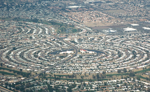
Two very different prognoses for the Sun Corridor
Much of the book focuses on projecting population growth and development out to 2040, in order to predict the continued importance of Megapolitan Areas well into the 21st century. Suffice it to say that the authors are pretty bullish on American growth, expecting it to continue in roughly the same trajectory it has been on for the last several decades, not withstanding our major housing hiccup. Seeing that Las Vegas and the Sun Corridor (Phoenix to Tucson) are slated to be among the fastest growing regions brought to memory an image from a couple of weeks ago. James Howard Kunster was addressing the CityWorks (X)po in Roanoke, Virginia. He showed an aerial photo of houses stretching into the Arizona desert, then quickly remarked, "oh yeah, and Phoenix is toast. There will be no Phoenix" before moving on to the next slide.

So what do you do when two people whom you respect differ in their forecast by ... oh, nine million or so? Well, you cut the difference. Kunstler is clearly being hyperbolic. There's too much vested capital in these Megapolitan Areas for even the worst-case scenario to simply erase them. On the other hand, Nelson and Lang could stand to internalize the possibility of resource scarcity into their projections. They've written a whole chapter on the pressure megapolitan growth will exert on farmland, water, and air quality, but they don't seem to accept that these pressures, in turn, will shape the built environment in a measurable way. For example, the authors point out that water use in the dry Sun Corridor, which is the highest per household in the nation, will have to be reduced somehow. But will those restrictions curtail business? Will future sunbirds be deterred if they can't have the lawn promised in the brochure? That's easy ... yes. Growth will slow down.

But quibbling about the exact distribution of population would be missing the point of the book, and the authors are appropriately cautious in the epilogue with looking so far into the future. The question is whether the definition of Megapolitan Areas will continue to accurately reflect the American pattern of development into the future. Charles Darwin noticed two kinds of taxonomists, the "lumpers" who saw few species and the "splitters" who saw many species. Likewise, reasonable people could look at the same Megapolitan Areas and see many metropolitan areas connected to each other rather than a single whole. Or even a whole galaxy of neighborhoods and employment centers.

This is not a problem. Really, we need as diverse a taxonomy as we have problems to apply it towards. The authors make a strong case for using the megapolitan scale for planning national rail infrastructure, which fits nicely because of the needed density and optimal range inherent to this technology. Some economic development efforts, at least for global markets, would work well at the megapolitan scale, but in other regional markets businesses and communities would be better served by competing with each other.

However, there are points in the book where it feels like the Megapolitan scale is being championed as a superior way of dividing up the nation, rather than just another tool with some good applications. I'm personally very fond of the terms "urban" and "rural" and everything they connote, so it would be sad to see these traditional distinctions melted away into one big megapolitan stew. After all, it's just as legitimate to use labels on the basis of how we want the world to be than on how it currently is. Megapolitan Areas also have the liability of not being exhaustive, which makes the old-fashioned state boundaries more appropriate for applications where complete inclusiveness is necessary.

I'm happy to think in terms of Megapolitan Areas and use the term in the way Nelson and Lang present it, along with several other geographical constructs that have their own appropriate uses.

Thursday, October 20

Instant City: Life and Death in Karachi

Reading a book by an NPR host is a different kind of experience. So was the case with Instant City: Life and Death in Karachi. As Steve Inskeep shares his impressions of Karachi's explosive urban growth, I could almost hear the subtle enthusiasm in his voice over the crunches of granola in my mouth. Fortunately, his skill for parring down complex subjects into bite-sized remarks translates well onto the written page.


Something like a city-wide version of Maslow’s hierarchy of needs shows up in various forms throughout the tale of Karachi’s growth. Faced with an ongoing tidal wave of immigrants from rural areas, urban planners and developers alike tried over the years to shape that growth into a desired form. However, in the absence of more basic government services such as security, sanitation, and public infrastructure these higher-level organizational schemes had no chance of actually working. If prospects did seem good for a moment, the regime would change and it would be all over.  In many cases, city officials and businessmen would import ideas from the West, often directly through global consultants, without paying enough attention to the very different political reality on the ground in Karachi.

The 50-year-old suburbs of Korangi and North Karachi are apt examples. Inspired by the West’s suburban expansion in the 1950s, Pakistan’s ruling general Mohammad Ayub Khan envisioned many of Karachi’s poor lifted into decent suburban lifestyles to the north of the city. With help from the Ford Foundation, the famous Greek planner Constantino Doxiadis was hired to create, from scratch, a self-contained community for at least a half million people. Doxiadis was careful to take design cues from local architecture and cultural preferences, but the design – and he recorded doubts about this in his journal all along– just could not be fitted to Karachi’s economic situation.

Although tens of thousands of families were relocated to these suburbs, problems arose immediately. First, the proliferation of privately-owned automobiles that made American suburbanization possible just weren’t there. Workers who had always walked now had to improvise bus services and pay to commute to their modest jobs across the city. Along with transportation, the residents just couldn’t pay for the houses they lived in, even with heavy subsidies. Without funds to continue, the city-building was cut short. Although Doxiadis had every intention of integrating rich and poor, the opposite happened. The suburb served as a mechanism for pushing the poor to the periphery of the city, which is how Karachi is arranged to this day. Finally, the carefully laid out designs eventually eroded away as unauthorized settlements filled in the open spaces and yards. The end result was the kind of informal settlement the entire endeavor was intended to alleviate - only now miles away from the center.

Other lofty goals were thwarted. A lavish casino had to be torn down before ever opening when the tide changed and the temptation that Muslims might gamble was no longer acceptable. A grassroots movement to save a national park from encroaching development ended with the assassination of two leading neighborhood activists. The essential functions of placemaking, whether from citizen-activists, developers, or planners, were all drowned out by the deeper needs of security and at least a certain degree of political stability. There is no use putting the cart before the horse.

Sunday, October 16

Visions for an Urban National Park

I'll admit that I had no idea a reasonably large national park existed within the boundaries of New York City. Even after a short-lived but legitimate childhood obsession with national park trivia, and after having worked in a national park in Wyoming for a little while, this urban recreational area escaped me. That is until opening Gateway: Visions for an Urban National Park, a book recently released from Princeton Architectural Press. It catalogs the collaborative effort between the National Park Service and a host of designers, mostly landscape architects, in telling the story of this park while continuing to write it.

Maybe I missed Gateway, because it has yet to find a clear identity. As Alexander Brash, a director in the National Parks Conservation Association, writes "Gateway really has no clear thematic past, nor has an easily recognizable and unifying vision for its future been embraced."
  • Gateway is split in to three units: Staten Island, the Jamaica Bay section of Brooklyn, and Sandy Hook in New Jersey. There's no clear way to tie them together. 
  • Gateway's history is split between a location of early native Lenape trails, the site of NYC's first airport, and America's largest World War II naval base. Less glamorously, it contains a quarantine island that housed sickly immigrants, as well as the final and gruesome destination for most of the city's 19th century transportation system. 
  • Gateway is an important estuary for migratory birds, but also a grand experiment in the remediation of over a century worth of unmitigated pollution. 
  • Gateway also functions essentially as a regional park for seven million people a year, allowing many to benefit from a national park who may otherwise never visit one.
The park's complexity is what makes it such a compelling topic for the design competition. Some of the ideas generated can be more feasibly implemented than others, but, in this case, that's fine. The goal was never to select an out-of-the-box design to be built but rather to generate a host of concepts that could help re-envision the park's future. While the NPS will never actually construct thousands of hydroponic pontoons and push them off into Jamaica Bay, the picture of these floating pods underscores Gateway's need to adapt to the shifting interface between water and land after climate change. This was a major theme that many designers picked up on.

Others focused on the park's almost teasing sense of accessibility. While located very near millions of people, it's barely out of reach of the subway and planned ferry services throughout between park sites never materialized. Jamaica Bay became another of Robert Moses' victims when he cut off access from Brooklyn neighborhoods with the Belt Parkway (although, to be fair, Moses also oversaw construction of the popular Jacob Riis park in Gateway). Many proposals tie together ferry lines, subway extensions, multiuse trails, and even overhead cable cars to unify the park and the city.

Of all the parks features, by far the greatest attention was paid to the abandoned Floyd Bennett Field,  with its crumbling runways and nameless structures scattered around. This is a canvas to good to pass up. An editor of the volume, Kate Orff describes Gateway as "post-picturesque," in contrast to Olmstead's Central Park.
"Just as Central Park's construction sharpened our concept of 'the public realm' for an industrializing New York City, re-envisioning Jamaica Bay as a thriving cosmopolitan ecology would further evolve the concept of public space based on stewardship and cultivated wilderness for post-industrial contexts."
If the National Park System has traditionally evoked transcendence through spectacular natural beauty or historic narratives, Gateway could be something different. One of the designs had members of the public walking through each stage of a water treatment process. From the point where the effluent flows in, through a series of settling pools,  and into a restored marsh. At first, I was skeptical. I doubted that families would really bother to follow the informational signage through this seemingly mundane process. But why not? Where else is this kind of story being told?

Tuesday, September 6

Which is denser: New York or Los Angeles?

Your intuitions are correct. New Yorkers live in neighborhoods with much higher density than do Angelenos. But its not obvious how this conclusion is reached, and there's plenty of confusion going around about measuring density. Where you draw the lines on the map can have a significant impact on the results you get.

If you measure density purely regionally, Los Angeles comes out ahead. I've used the Census Bureau's MSA to show the two metro area's population densities in 2010. Sometimes the geography of Urbanized Area is used to capture the region, but that hasn't been determined for 2010 yet. So the MSA will do ...


However, this measurement misses the important story. As Ryan Avent explains,
"Simple population density measures the average density across a particular area. If you have a metro that covers a large area but which features a very dense core, however, you can easily have a situation in which the vast majority of the metro’s population lives at densities above the average population density. I think it’s more informative to focus on weighted-average population density."
  So here's the weighted-average density (by census tract) for the two metro areas:


New York metro goes from being about 30% behind LA in regional density to more than doubling LA in average neighborhood density.

If you were to drop from a parachute flying over the center of a city on a very windy day, the first regional density figure would tell you how many people to expect to see in the square mile around the random place in the region you land. However, if you currently live in the New York or Los Angeles metro areas (or are considering moving there), the latter figure would tell you how many people you would expect to see in the square mile around you. It's tethered to actual human experience, which is usually what we are asking about when we talk about density.

Thursday, September 1

London Bus Tour

This is a wonderful video shot during a course of 30 hours riding a London bus. Every person the bus passes seems to have their own story, even if only captured in two-second film clips. I don't think I've seen a more humane portrait of a great city.


London Bus Tour from moritz oberholzer on Vimeo.

Saturday, August 27

Harlan Douglass: The Little Town

I've decided to resume reviews of books from the the first wave of City Planning in the early 20th century. I'm reading them because a) they're free (copyright expired) and b) there might be something to learn from this period that still applies. Here's the list so far:

  1. Garden City - Ebenezer Howard
  2. Town Planning in Practice - Raymond Unwin
  3. City Planning with Special Reference to Planning of Streets and Lots - Charles Robinson
  4. New Ideals in Planning - John Nolen
  5. The Little Town - Harlan Douglass
  6. Cities in Evolution - Patrick Geddes (upcoming)
All of these reviews are truthful, but they are also selective and editorial. I'm not a trained historian; I only play one on TV. In other words, don't steal this for your class paper. I don't care, but you're professor probably will.

The Small Town Ideal

Americans, today, have a schizophrenic relationship with small towns. We consistently tell pollsters that we want to live in one above any other kind of place, yet we just as consistently choose not to. The Atlantic just ran a story about an idyllic small town in Missouri that, like many around the county, can not attract enough doctors. They've determined that it's not the economic incentives, but the lifestyle that's deterring them. Even small towns that have been engulfed by expanding metro areas tend to receive a scant share of the new arrivals compared to the exurbs around them. Yet the ideal lives on and we like imagine ourselves on the inside of a tight community as we enjoy, at the same time, our freedom from its responsibilities and constraints.

The small town ideal did not exist in 1921. Harlan Paul Douglass wrote The Little Town especially in its rural relationships as a heartfelt defense of what was, in the eyes of many, a pitiable character. He quotes the president of the American Civic Association: "God made the country, man the city, but the devil the little town." From the urban perspective, the townsfolk were unsophisticated, incurious, and many steps behind the moving edge of history. At the same time, rural areas were being lauded by the "county life movement," which had made substantial inroads into the federal government. The farmer was the hero, and the townsfolk were, at best, parasitic middlemen and, at worst, emissaries of corruption from the big city. Farmers were beginning to pull their kids out of town schools and look for a nice field to start their own.

Those who lived in little towns were no easier on themselves. They wanted nothing more than to be the next Chicago, and this overwrought ambition led many to foolishly invest in lavish infrastructure only to be bypassed by the railroad company and left with a dusty, wide main street. Douglass wanted to study and plan for the little town, along with its connected rural areas, as a kind of place that deserved its own category. His aim was to "make it the centre alike of inspiration and administration in the reconstruction of rural civilization."

The Walkable Town

Douglass noted that the maximum size of a town was a function of the walking radius from a single core, enough room for about 5000 people at most. This was the threshold before investment in streetcar lines would have to be justified, creating a natural plateau. With public buildings and business operations at the core and residences surrounding it, every person remained connected to the same sphere. Even the women busy tending their homes could still make it downtown several times a day. The outer ring of the town he calls the "black belt." These were the slum-farms that invariably popped up just outside of a comfortable walking distance but not far enough away to require a motorcar or a team of horses. The farms were small and their buildings created a depressing entrance corridor into the town.

The scale and common center of a town created a unique physical space for diverse interactions. According to Douglass, "no other community enjoys such close daily fellowship with men of so wide a range of vocation or calling." Professional classes in the larger cities would cluster in distinct social groups and neighborhoods, but the size of the small town forced interactions across these lines. Yet there were also physical features of many towns that did create an impediment to interaction. Groups lived on the "other side of the tracks" or "across the river." In these cases mere physical access was directly translated into economic and social access. Douglass believed that,
"a well-planned town with its civic centre is both a means and impulse to social integration, and to the realization of the common life of its people. The physical plan to a town is this as fundamental as the skeleton to the human organism."
This is a notable stance to take, considering that some other planning advocates were, at the time, considering how zoning could be used to properly separate social classes from one another.


The Natural Political Unit

The primary aim of Little Towns is to depict individual towns and their surrounding countryside as interdependent units making up a single "natural community." Despite the significant differences in lifestyle - rural areas were still without electricity - and cultural outlook, the two kinds of places relied on each other economically and socially. Proving that tacky neologisms have always been with us, Douglass liked to use the work Rurban to describe this synthesis.

A central problem consisted in the mismatch between these natural communities and existing political boundaries. So, for example, a farmer would need to travel into town to sell crops, buy goods, and attend church, yet the incorporation of town limits precluded him from the political sphere. The farmer was not expected to pay taxes for the town's function, and he did not have a voice in town matters. Towns compensated for this imbalance by taxing trade, which Douglass believed was underscoring an antagonistic relationship. The farmer then viewed the town as a miniature fiefdom funneling away a portion of his labor, rather than as his own community. For their part, townsfolk considered their rural counterparts to be outsiders.

Douglass believed this could be remedied by a simple exercise. Conduct a scientific town survey to determine the trade area, the availability and use of roadways, and the social identification people declare. Once a map has been made empirically showing the use of services and town identity, the arbitrary political boundaries should be replaced with new ones that match reality. If necessary, multiple zones drawn concentrically from the core outward could be created to define classes with different service needs and different funding responsibilities. Interestingly, Douglass' approach is very similar to later regionalists like Louis Mumford or, much later, Myron Orfield, only at the much smaller rural scale.

As enticing as this solution appears, there remains the challenge of geographical change to deal with. The boundaries of the natural community are always shifting, yet institutions are much stickier. Not only must local governments deal with the transaction costs of redrawing jurisdictions on a regular basis, vested interests start to accrue over time that eventually solidify the boundaries as they are. Annexation was the tool used to deal with spatial change for many years, but this has become politically impossible in most regions. There has yet to emerge another tool that effectively accomplishes what Douglass set out to achieve.


Saturday, April 16

New study sheds light on roadway safety for all

Traffic safety has been one of those long-standing fault lines in the purported war between cars and pedestrians. In the one corner, we have traffic engineers who are given the task of designing roadways to maximize speed and capacity, while maintaining what is considered an acceptable level of safety for motorists. You do this by making the roadway as forgiving as possible with wider lanes, longer sight distances, and nothing to crash into along the side of the road. In the other corner, pedestrian advocates have insisted on slowing cars down with traffic calming, on-street parking, pedestrian signal prioritization and lots of other strategies to look after their own safety. As the story goes, each side is locked in a shouting match over whose safety is the most important.

Design Solutions for Balancing Traffic Conflicts and Speed. Source: Dumbaugh et. al.
But a new study that appears in the Journal of the American Planning Association sheds more light than heat on the subject. Eric Dumbaugh and Wenhau Li found that designs that make the travel safer for any road user make travel safer for every road user. Really, there is no zero sum game. We don’t have to pick one team. Thankfully.

The researchers looked at almost 300,000 crashes in the San Antonio area and considered all of the details of where the crash happened, not just how many cars use the road or how wide the lanes are. They asked: Is this a pedestrian-scaled “Main Street” or is it an arterial lined with strip malls? Are there big box stores around? How many intersections are in the area, and how many people live nearby? Then they considered who was involved in the crash. Two vehicles? A vehicle and cyclist? A vehicle and a tree? With all of these variables in mind, they determined which factors were better correlated with a safer environment … and for whom.

The results may not entirely satisfy either side, but they make sense. Freeways turn out to be pretty safe, showing a relatively small proportion of crashes. This probably has more to do with the lack intersections on highways, than it does the opulent shoulders and smooth grades. With access limited to a few exits and entrances, there are just fewer chances to collide with an oncoming vehicle. But just as the highway engineers may consider theories are vindicated, the research shows that places on the opposite end of the spectrum are just as safe.
The presence of pedestrian-scaled retail uses, on the other hand, was associated with significant reductions in multiple-vehicle, parked-car, fixed-object, and pedestrian crashes. We attribute this to reduced vehicle speeds. Street oriented buildings create a sense of visual enclosure of the street, communicating to the driver that greater caution is warranted, and resulting in reductions in both vehicle speed and crash incidence.”
Consider all of the chaos of a Main Street scene. A driver is trying to parallel park while a cyclist dodges the opening door. Pedestrians are crossing at will, and delivery trucks are backing into their spaces.  Visual stimulation is everywhere. The old engineering models would take all of these inputs and calculate a daily bloodbath, but nothing of the sort is happening. It’s a highly functional environment. The key here is that both the Main Street and the Freeway are relatively safe for all road users, motorists and pedestrians alike (although let’s admit that pedestrian safety on the freeway is purely a function of their non-existence).

The absolute worst places for everyone were the ones that fell between the cracks of the two paradigms. There’s one of these in your town. The wide highway with a traffic light every few hundred feet leading into strip shopping centers. They are designed to be Freeway-esque with plenty of room for you to veer out of your lane, yet with all of the conflicts of cars pulling in and out still there. These precautions are just a cruel trick, inducing drivers to take on more speed than they really should to their own detriment. Pedestrians are caught in the cross-fire with no armor, and before you judge them for having the audacity just to be there, remember that many service-sector workers have no choice. In the twentieth century we dreamed of the best of both words for our roadways – access and speed! - but ended up with the worst of both worlds.

Freeways will still be utilized for those long-distance trips between cities, at least while gas is still relatively inexpensive. They should continue to be designed to handle the high speeds they command, to allow drivers to travel safely. But within highly-concentrated urban areas, mindlessly applying these same standards wrecks havoc. In these cases, a design approach that takes into account the whole context of the street yields a much safer result for pedestrians and motorists alike.

Friday, February 11

Where does a revolution happen?

In an historic sequence of events for the nation of Egypt, massive demonstrations were held at the Nile View mall in suburban Cairo. Protesters began gathering outside of J.C. Penney in late January. Within a week the parking lot was full, and traffic was backed up for miles with eager activists waiting to enter. The food court was taken over as a makeshift shelter, and new vendors popped up to compete with Sbarros and Panda Express to feed the demonstrators. When Hosni Mubarak agreed to step down, the elated crowds moved into the multiplex movie theater for celebration. Historians believe this may be the first revolution in world history entirely set to the soundtrack of smooth jazz.

No, wait. None of this is happening.

Photo taken by Flickr user Ramy Raoof

Democracy for the nation of Egypt was won in Tahrir Square, right in the heart of Cairo. Tahrir Square is surrounded by museums, governmental offices, universities, stores and hotels, and many, many compact neighborhoods, making it a natural epicenter of human activity and the obvious site for political action. Being one of the mostly densely populated cities in the world, thousands of protestors can converge in the center and meet with others from across the socio-economic range. Protestors flooded into the square through the Egypt Metro system, one of the busiest in the world. Although authorities tried to quell the demonstration by blocking the square’s Metro stop, many of the participants have been getting off at nearby stops and walking the rest of the way in.

Edward Glaeser pointed out in the New York Times last week that “it’s always the urban pot that boils over.” Cairo, Egypt and Tunis, Tunisia are only the latest installments in the tumultuous story of cities.
Cities are places of revolution, because urban proximity connects organizers of opposition. Large urban populations create the scale needed to initially overwhelm local law enforcement … The constant interaction of human energy in dense clusters creates innovations in every area of human life, including politics.”
All the tweets and texts flying through the airwaves have not changed the fact that a physical place, a public square in the most literal sense, will always be a necessary stage for any kind of action. You know, in reality.

Here’s Sarah Goodyear writing in Grist,
The government of Hosni Mubarak could shut down the internet. It could shut down cell phone service. It could force Al Jazeera, which has been providing superb coverage of the events in Egypt, to close its Cairo bureau. It could arrest journalists and seize their equipment.

But the streets of Cairo themselves have been the medium that has carried the message of the Egyptian people. So have the streets of Alexandria, Suez, and other Egyptian cities. And the government's efforts to keep people off those streets have failed completely."
And Tahrir Square was not just a convenient place to hold a rally. Hey, we're about equidistant between most of our homes, plenty of space to work with, let's start gathering here. No, the fact that the message was brought to the center of the capital city itself conveyed meaning. The central public square is likewise the impromptu location for celebration.

Friday, January 28

Michael Sandel on public places

                                                            Source: Harvard Gazette
I was pleased to see Michael Sandel’s name show up as a keynote speaker at this year’s American Planning Association conference. He’s a well-known Harvard political philosopher who has made a career out of pushing the boundaries of how we talk about right and wrong toward the notion of the common good. But what does high-minded ethical reasoning have to do with planning the places we live in? As I would find out, quite a bit.

I turned to Sandel’s most recent book, Justice: What’s the Right Thing to Do, based on a course he’s taught for the last two decades (which happens to also be a hit on Japanese TV, oddly enough). It’s jam packed with those thorny moral dilemmas that are great fun to subject your friends to. After running through the answers given by the usual suspects throughout history, he finishes out the book with his own position. Here’s one salient point:
An earlier generation made a massive investment in the federal highway program, which gave Americans unprecedented mobility and freedom, but also contributed to a reliance on the private automobile, suburban sprawl, environmental degradation, and living patterns corrosive to community. This generation could commit itself to an equally consequential investment in an infrastructure for civic renewal: public schools for which rich and poor alike would want to send their children, public transportation systems reliable enough to attract upscale commuters; public health clinics, playgrounds, parks, recreation centers, libraries, and museums that would, ideally at least, draw people out of their gated communities and into the common spaces of a shared democratic citizenship.”
To see how he lands here, we’ll have to back up a little to grasp the underlying principles. Sandel calls into the question the modern notion of grounding all of ethics in the consent of individuals, instead reaching back to Aristotle and the notion of a civic order that encourages a strong character that looks outward from itself. Asking anyone today to honor the public good seems even a little quaint, and cynics are ever looking for the angle, but Sandel is serious about reviving the calling of citizenship.

He notes that our public discourse has come to revolve almost entirely around personal rights and personal demands. On the right, this means defending the economic decisions to buy and sell as you wish. On the left, it means breaking away from the shackles of traditional social mores and leveling inequalities. Your choices are: either let everyone keep the resources they earn in the marketplace or redistribute resources to the individuals who have more of a need. But both sides seem to agree that we are essentially individuals. We may engage in relationships or associate ourselves with certain groups, but only as long as our personal goals are achieved in the process.

How does this philosophy translate into our physical places? It means big private homes and small public spaces, many yards and few parks, lots of driving alone and little public transportation, gated communities with or without the literal gates – basically a whole place arranged so that we will never have to see a neighbor or a stranger unless we specifically choose to. We could say all sorts of things about the fairness or sustainability of this arrangement, but Sandel raises another point. This kind of place makes it harder for us to build the character traits we look up to: courage, solidarity to a community, mutual respect, sacrifice for the good of others. You can’t just read about being a good person. It takes some training and a practice field.

To pluck a story from the Christian tradition, when an injured Jewish traveler was lying along the side of a road, it was the Samaritan, his sworn ethnic enemy, who decided to lend a hand. This scene was Jesus’ response to the question “who is your neighbor?” We may like to think of ourselves as similarly generous, but we forget that the Samaritan had to actually walk past the injured man in the first place just to be presented with the dilemma.

This might be what Sandel means by an “infrastructure of civic renewal,” a full-bodied public realm that may be more challenging – alas, we don’t all agree about what the good life should be – but one that will strengthen us through the give and take of a wider community. And this can’t happen if we don’t build places to facilitate these interactions.

Monday, January 3

Framing the Ethics of Metropolitan Growth

Source: Continuum
I'll come right out and say that Ethics of Metropolitan Growth is a wonderful resource. Robert Kirkman is a philosopher employed in the realm of public policy by Georgia Tech, and he has obviously poured significant amounts of experience and reflection into this relatively short book. Without an ounce of jargon and very little academic name-dropping, it really is refreshing to read. He drills down to the basic questions of what we want out of the place we live in.

[By the way, please don't confuse my effusive praise for any compensated endorsement. That wouldn't be very ethical, would it?]

The book tours through many of the planning and design decisions we make in our communities, revealing the tangled knot of values and intentions that will be immediately recognizable to anyone who's been to more than a few public hearings or read through comment threads from the whole spectrum of websites. Complicated? Sure, yet he neither leaves us awash in moral ambiguity nor sets up any side in particular on the moral high ground, from which grenades of judgment can be lobbed on the opponents below. He simply builds a framework to help anyone sort through their own goals and compare them with the goals of others.

Kirkman's outlook on ethics, in general, is very modest. He accepts that every decision is uniquely determined by the situation it's embedded in, so no single rule can be applied across the boards to supply the right answer to a question. By extension, this means that blame (or praise) is often very difficult to discern. He also refuses to take sides on any of the perennial debates philosophers engage in over ethics. Is it the consequences of the action that counts? Is it the motivation behind the action that counts? Is it the character of the person acting that counts? All of the above, Kirkman says. He can do this, because he isn't really looking for a way to splice right from wrong but simply a way to think about right and wrong.
"The point is to ask critical questions about each view, to examine its scope and its limits. to test whether it holds together and whether it can be put into practice."
To be honest, this does come across as too modest for many topics. Most of us want to be able to conclude that raids on innocent villagers in the Darfur region of Sudan are flat-out evil, rather than suggest that the raider engage in some serious reflection over whether his intentions are internally consistent or not. But the book isn't about genocide. It's about zoning. And how to get to the store. The hushed, cerebral tone is completely appropriate. To the neighbor shouting down a greedy developer or the dude waiving a shotgun at anyone who will meddle with his property, Kirkman says: relax, let's think it through.

Source: Encyclopedia of Earth
So how do we do that? The framework he presents is better than anything out there. I've been taught a technique called the triangle of sustainability, otherwise known in business terms as the triple bottom line, for making planning decisions. I've always found it to be awkward. You're suppose to balance between economic development, environmental protection, and social equity, all under the banner of "sustainability" which then immediately buckles under the weight and collapses into utter meaninglessness. The terms are not well matched up to each other, and there's no real advice for actually making the trade-off (which is really the whole source of conflict). The triangle also doesn't touch on the important question of who should be making the decision anyway.

Kirkman's framework starts with a place-based spin on Aristotle's classic quest for the good life. Since our lives are necessarily shaped by the environment that surrounds us, the issue becomes whether a place either constrains us or enables us to seek the good. We won't all agree on what the good life is, but at least we can have some clarity on how the built environment overlaps with these personal goals. The second consideration is how the identified good is distributed among people. Is it fair? The third consideration is how the identified good is distributed through time. Will it last? Finally, there's the question of process.

Source: Ethics of the Built Environment
Consider the suburban ideal of living in a private, detached house halfway between nature and culture, possessing the best of both worlds. Those who embrace this as their preferred lifestyle could check off each item on the well-being list, but moving to justice and sustainability reveals some difficulties. If others were to follow suit and move into the neighborhood, the balance is upset toward density and it no longer feels so natural. Therefore, you impose regulations to exclude others, which should be problematic if you consider yourself a person who values fairness. And given that land and energy is finite and human population keeps growing, it's not at all clear that this arrangement will last. Do you want your grand-children to also enjoy this life? Here is the underlying contradiction behind the old joke: sprawl and density are the two things people hate most. The point of the framework is to force a resolution between these competing personal goals.

He doesn't let New Urbanists off the hook either, pointing out how often they present a false choice between an idealized traditional town and the most chaotic of modern suburbs. This is unnecessarily limiting. One of the points of engaging in the ethical exercise is to hunt for new possibilities that had previously been ruled out or missed entirely. It should spur creativity and reveal win-win solutions that meet the unstated preferences lurking beneath some of the stubborn public positions we take.

This is a good list, but I can't pass up griping about including mobility as basic to well-being. Most of us value getting to the place we want to go (accessibility), not just moving from one place to another (mobility). Achieving access usually includes mobility, but it also includes proximity, or not having to move very far to get to where you want to go. Although this seems like splitting hairs, setting access as the ultimate goal of a transportation system completely changes how performance is measured and projects are selected. Just had to throw that in.

One of the more intriguing discussions is over the legitimacy category, especially the scale of the decision. We don't act only as individuals, but also as groups. Even the most ardent libertarian will accept that sometimes decisions should be collectively made, even if he'll insist that this be voluntarily entered into (i.e. marriage, joining a Homeowners Association) and an eject button is readily available (i.e. divorce, leaving the HOA). The rest of us are even more comfortable with power vested in a range of organizations, as long as we are represented fairly in decisions the group makes.

As in the example to the left (my own), a similar inquiry can be broken down across different scales, typically matched with different ranges of time as well. Each expression exerts cause and effect on the rest, making it hard to pin-point any one as the ultimate reason for the way things are. Kirkman writes,
"To the extent all of the different ranges of government pull against one another, each asserting its own rights and prerogatives, there is less likely to be an effective response to problems in the built environment. Perhaps most important, there is often a mismatch between the scale of problems and the scale of government authority with the power to address them."
This leads him to point out the lack of effective regional bodies in American politics, not because a region is the optimal vantage point for all planning decisions but simply because it happens to be underrepresented. The issue of affordable housing is a classic regional problem. Almost everyone values a sufficient amount of housing affordable to residents with the range of incomes somewhere in their region, but the same people start having reservations about putting it in their own neighborhood, and few homeowners want to see their own  home become more affordable. Approaching this problem with too small a scale, and you get inefficient fragmentation; too large a scale, and you're apt to be insulated from what citizens actually want for their own community. For this particular question, the region seems just about right.

Kirkman is not so much of a philosopher to insist on subjecting every single decision to this level of scrutiny. He acknowledges that even stepping off the front porch, "I could find myself paralyzed, my foot poised eternally above the pavement, unable to take a single step while the deliberation goes on." Practically, we need to use reflexive behaviors and snap-judgments about the built environment. But the reader of this volume is treated to at least of a few hours of time to stand back and reflect on these habits of thought about the places we live in. It's a worthwhile exercise for any of us.